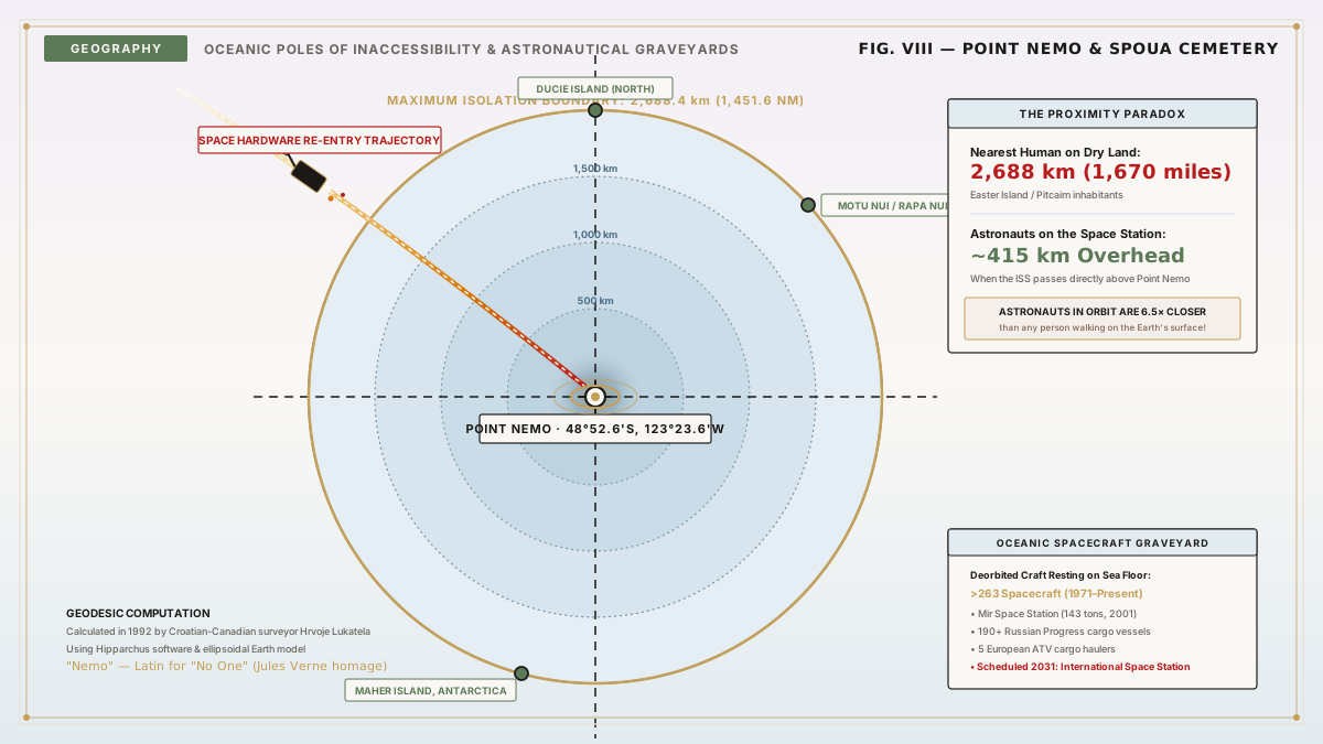
In the boundless expanse of the South Pacific Ocean lies an invisible geographic coordinate: 48°52.6′S 123°23.6′W.
There is no island here. There is no sandbar, no submerged coral reef, no oceanic weather buoy, and no offshore drilling rig. The ocean surface looks entirely indistinguishable from millions of square kilometers of surrounding gray-blue swells. Yet this precise mathematical spot is unique on Earth. It is the Oceanic Pole of Inaccessibility, colloquially designated Point Nemo—named in homage to Jules Verne's enigmatic submarine commander in Twenty Thousand Leagues Under the Sea (Latin for "no one").
Point Nemo is the single most remote point from dry land on planet Earth. To stand on a ship at Point Nemo is to be isolated from human civilization to an astonishing degree: the nearest landmasses sit precisely 2,688 kilometers (1,670 miles) away in three distinct directions.
Because commercial maritime shipping routes bypass this barren oceanic desert, the closest human beings to Point Nemo are almost never mariners or islanders. They are the astronauts aboard the International Space Station (ISS), orbiting 415 kilometers (258 miles) overhead in low Earth orbit.
"Point Nemo is the loneliest coordinate on Earth: an oceanic void so far from continents and islands that human beings in space are six times closer than the nearest person standing on solid ground." — Hrvoje Lukatela, Croatian-Canadian Geospatial Engineer (1992)
Calculating Inaccessibility: Hrvoje Lukatela's 1992 Algorithm
Historically, locating poles of inaccessibility was notoriously imprecise due to the complex ellipsoidal geometry of Earth. A sphere can be mapped simply, but Earth is an oblate spheroid, flattened at the poles and bulging at the equator.
Point Nemo was calculated in 1992 by the Croatian-Canadian survey engineer Hrvoje Lukatela. Recognizing that traditional paper maps distorted geodesic distances, Lukatela engineered a specialized geospatial computing program called Hipparchus:
- The software modeled the three-dimensional WGS 84 ellipsoidal geometry of Earth.
- It performed an iterative calculation to locate the center of the largest possible circle that could be inscribed on the planetary surface without touching a single coastline, reef, or island.
- The resulting circle has a radius of 2,688.4 kilometers (1,670.5 miles) and an area of approximately 22.7 million square kilometers—larger than the entire continent of South America.
The circumference of this empty circle is anchored by three equidistant, uninhabited islands:
- Ducie Island (part of the Pitcairn Islands) to the north.
- Motu Nui (an islet off the southwest tip of Easter Island) to the northeast.
- Maher Island (off the coast of Marie Byrd Land, Antarctica) to the south.
Each of these three isolated specks of rock sits exactly 2,688.4 kilometers from Point Nemo.
                  [ Ducie Island ] (North)
                  2,688.4 km
                        \
                         \
                          * POINT NEMO (48°52.6'S, 123°23.6'W)
                         / \
                        /   \
  [ Maher Island ] ----      ---- [ Motu Nui ] (Northeast)
  (Antarctica - South)            (Easter Island)
  2,688.4 km                      2,688.4 km
The Biological Void: The South Pacific Gyre
One might assume that an oceanic expanse undisturbed by human commerce, fishing trawlers, and plastic pollution would be a pristine marine sanctuary teeming with whales, sharks, and pelagic fish.
The oceanographic reality is the opposite: Point Nemo is a biological desert.
Point Nemo sits directly in the center of the South Pacific Gyre—a colossal circular ocean current rotating counter-clockwise across millions of square miles. The dynamics of the gyre create an extreme marine wasteland:
- Downwelling Currents: The rotation of the gyre forces surface waters downward, preventing deep, nutrient-rich bottom waters from welling up to the sunlit surface.
- Extreme Distance from Land: Marine primary productivity relies on terrestrial dust carried by winds, which supplies critical trace minerals such as iron to ocean water. Point Nemo is so vast distances from continental landmasses that atmospheric dust deposition is virtually zero.
- Hyper-Oligotrophic Water: Without iron, nitrates, and phosphorus, phytoplankton cannot bloom. Without phytoplankton, there is no zooplankton, no krill, no pelagic fish, and no apex predators.
Satellite ocean-color sensors show that the waters surrounding Point Nemo have the lowest concentration of chlorophyll anywhere on the planetary ocean. The water is so biologically sterile that it exhibits record-breaking optical clarity: deep sunlight penetrates over one hundred meters into the crystal abyss.
The Spacecraft Cemetery: Where Satellites Go to Die
Because Point Nemo combines total human absence with minimal marine life and zero maritime traffic, it serves as humanity's official Spacecraft Cemetery (officially termed the South Pacific Ocean Uninhabited Area by international aerospace agencies).
When large satellites and orbital stations reach the end of their operational lifespans, atmospheric drag slows them down. Small satellites burn up completely into harmless vapor during the searing heat of atmospheric reentry. However, massive multi-ton space vehicles—such as rocket stages, cargo freighters, and space stations—contain heavy titanium fuel tanks, reaction wheels, and beryllium heat shields that survive the 1,500°C reentry inferno.
If a 100-ton space station were allowed to tumble through uncontrolled reentry, high-speed debris could rain down across densely populated cities.
Space agencies (including NASA, ESA, Roscosmos, and JAXA) program de-orbit thruster burns to target Point Nemo as their oceanic impact footprint:
- Between 1971 and 2026, space agencies have de-orbited more than 263 spacecraft over Point Nemo.
- Notable residents of the abyssal graveyard include the Soviet/Russian Mir space station (143 tons, deorbited in March 2001), six Russian Salyut stations, and dozens of European Automated Transfer Vehicles (ATV) and Japanese HTV cargo vessels.
- The ultimate deorbit: In 2030–2031, the International Space Station (ISS)—weighing more than 440 metric tons—will be decommissioned and targeted for a controlled terminal descent directly into the watery graveyard of Point Nemo.
Today, the shredded, titanium skeletons of dozens of humanity's most ambitious space missions lie scattered across the Pacific abyss, four kilometers beneath the surface, guarded by eternal cold and abyssal pressure.
The Bloop: Separating Cryptids from Cryoseismology
In the summer of 1997, Point Nemo surged into popular folklore when the U.S. National Oceanic and Atmospheric Administration (NOAA) detected an ultra-low-frequency underwater acoustic signal across equatorial hydrophone arrays positioned over 5,000 kilometers apart.
Dubbed "The Bloop," the acoustic waveform was extraordinarily loud—vastly more powerful than any sound produced by a blue whale. Because the sound originated only 1,750 kilometers from Point Nemo, and because author H.P. Lovecraft had coincidentally placed the sunken fictional city of R'lyeh (the prison of Cthulhu) at nearly identical South Pacific coordinates (47°9′S 126°43′W), the internet erupted with speculative monster lore.
The scientific reality, confirmed by NOAA seismologists in 2012, was geological rather than biological. The Bloop was generated by a massive icequake—the catastrophic fracture and calving of a gargantuan glacial iceberg off the Antarctic ice sheet. The crack of fracturing ice radiated powerful low-frequency acoustic energy across the SOFAR channel, perfectly explaining the acoustic frequency and extraordinary amplitude of the recording.
Key Takeaways
- The Ultimate Inaccessibility: Point Nemo (48°52.6′S 123°23.6′W) is the point on Earth furthest from any land, sitting 2,688.4 kilometers from the three nearest uninhabited islands.
- Closer to Astronauts: The closest human beings to Point Nemo are typically astronauts on the International Space Station, orbiting 415 kilometers overhead.
- Biological Desert: Located inside the South Pacific Gyre, downwelling currents and near-zero iron deposition make these waters among the most sterile and clear on Earth.
- Orbital Graveyard: More than 260 decommissioned spacecraft, including the Mir space station and the future ISS, have been deliberately crashed here to protect human populations.
Oceanographic Surveys & Aerospace Trajectory Documents
- Lukatela, Hrvoje. "Point Nemo: Computational Determination of the Oceanic Pole of Inaccessibility." Hipparchus Geodetic Archives, Calgary, 1992.
- National Aeronautics and Space Administration (NASA). International Space Station Transition Plan. NASA Technical Reports Server, 2022.
- European Space Agency (ESA). "Deorbiting Strategies and Controlled Reentry over the South Pacific Ocean Uninhabited Area." Space Debris Office Technical Note, Darmstadt, 2018.
- Fox, Christopher G., et al. "Acoustic Detection of Cryoseismic Icequake Events in the Southern Ocean." Journal of the Acoustical Society of America, vol. 112, 2002, pp. 2400–2407.