What Is Virga, the Rain That Never Reaches the Ground?
What is virga? Precipitation that evaporates mid-air, fools weather radar and can precede microbursts. The science of the rain that never reaches the ground.
Key takeaways
- Virga is precipitation that evaporates or sublimates before it reaches the ground, usually over hot, dry regions.
- Weather radar can still detect it aloft, showing rain that no one on the ground will ever feel.
- Evaporating rain cools the air sharply; shafts of virga can precede dangerous microbursts.
- In desert regions, cumulus cloud bases sit 3-4 km up, giving falling rain plenty of time to vanish.
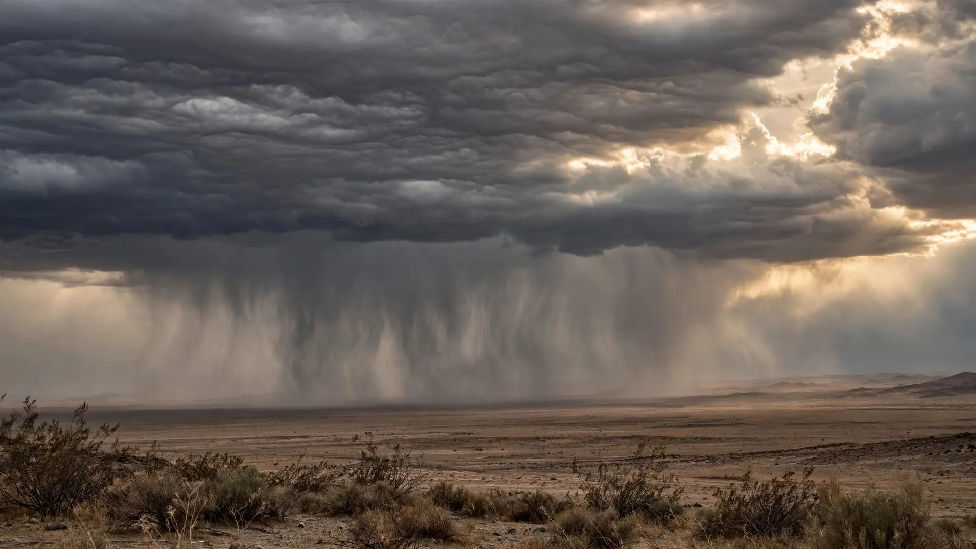
Virga is rain that falls from a cloud and evaporates before it touches the ground. It shows up as gray streaks or wisps hanging beneath a cloud, and the single most startling thing about it is that your weather radar can see it clearly while your skin stays perfectly dry.
What exactly is virga?
The National Weather Service defines virga in one clean sentence: "Streaks or wisps of precipitation falling from a cloud but evaporating before reaching the ground." The definition adds that in certain cases, shafts of virga may precede a microburst (National Weather Service). The word itself is Latin for a streak, stripe or branch: a fitting name, since virga looks like pale gray paint strokes hanging under a cloud. It is not a special kind of rain. Any rain or snow can become virga if the air below the cloud is thirsty enough. Liquid drops evaporate on the way down; ice crystals sublimate, turning straight from ice to vapor. By the time the precipitation reaches where your head would be, it has already become invisible water vapor. This is where clouds begin their lives, and why clouds stay aloft explains the delicate balance that keeps all that water hanging in the sky in the first place.
Why doesn't virga reach the ground?
Precipitation needs moist air beneath the cloud to survive the trip. When the layer of air between the cloud base and the ground is dry, falling rain evaporates before it arrives. The deeper the dry layer, the worse the rain's odds, a fact the National Weather Service's Louisville office uses to explain baffling radar images. "The deeper into the dry air mass you go, the less chance the rain has of reaching the ground," its explainer says. The radar will still detect the rain aloft, but you may not see it at the surface. This is one reason droughts are so hard to break: the rain you get is reduced because of the dry air in place (National Weather Service Louisville). Desert regions are the classic stage for this drama. Cumulus cloud bases there sit 3 to 4 kilometers above the ground, and that height gives falling drops a long gauntlet of warm, dry air to cross. On dry days the precipitation can evaporate completely before reaching the ground (Ludlam, 1980, as summarized in a 2023 peer-reviewed study) (Atmospheric Measurement Techniques). Converted, 3-4 km is about 1.9-2.5 miles of dry sky: a lot of thirst to walk through.
Evaporation is also a powerful cooler. Water has a very high heat of vaporization (40.65 kilojoules per mole, or 540 calories per gram), so turning liquid rain back into vapor soaks up a significant amount of heat energy from the surrounding air. The cooling makes air parcels denser, and dense parcels sink. Those sinking parcels are exactly what can become microbursts (Atmospheric Measurement Techniques). The journey from cloud to vapor can be measured in stages:
| Stage | What is happening | What you see |
|---|---|---|
| 1. Cloud release | Rain or ice leaves the cloud base | Dark cloud with a clean bottom edge |
| 2. Dry descent | Drops fall into warm, unsaturated air | Gray streaks lengthening beneath the cloud |
| 3. Evaporation | Drops absorb heat and turn to vapor | Streaks fading, the lower ends dissolving |
| 4. Cooling | The air chills and moistens, parcels sink | Wisps curling downward, sometimes a dust gust |
| Scientists now measure this process directly. A 2023 study used ceilometer laser data from the University of Texas at El Paso campus, from 2015 through 2021, to systematically identify virga events. The team found 50 virga events in those seven years, clustered in a clear seasonal pattern, and during some of the events, dust and pollution levels at the surface suddenly spiked as the evaporated droplets dumped their dissolved particles into the lower air (Atmospheric Measurement Techniques). |
How does virga affect weather and air quality?
First, it deceives. Satellite and radar systems that estimate rainfall from above keep getting fooled. A 2018 global analysis found that virga accounted for about 50 percent and 30 percent of false precipitation events detected by two spaceborne instruments (the Tropical Rainfall Measuring Mission's Microwave Imager and the Global Precipitation Measurement mission's imager) over arid regions. Rain that never reaches the ground still shows up in the data (Atmospheric Measurement Techniques). Second, it fights drought. As the Louisville weather office points out, dry air eats the rain before it can water anything, which helps explain why established droughts resist breaking. The precipitation exists; it just never gets delivered.
Third, it can be genuinely dangerous to aircraft. The 2023 study notes that cold air parcels descending during virga can produce wet or dry microbursts, which pose an extreme danger to small planes. The paper cites the 1975 crash of Eastern Airlines Flight 66 while approaching John F. Kennedy International Airport in New York on June 24, 1975: the downburst wind shear involved in that crash is what pushed scientists to name and study the phenomenon. Research from the Joint Airport Weather Studies project later associated dry microbursts with virga shafts using Doppler radar (Atmospheric Measurement Techniques). And fourth, virga leaves fingerprints on the air itself. The El Paso researchers classified their 50 events as columnar or non-columnar based on the aerosol profiles; 20 were columnar, and during some of those, surface particulate matter levels displayed a sudden upward trend, indicating aerosol loading in the surface layer after the precipitation evaporated. When the droplets vanish, the non-volatile components they carried (chlorides, sulfates and similar compounds) stay behind as airborne particles (Atmospheric Measurement Techniques). Rain comes in many forms between cloud and soil: freezing rain survives its fall in a different way, and desert dust storms show what happens when the dry air wins completely.
What do people get wrong about virga?
The biggest misconception is that the radar is lying. It is not. Radar measures precipitation in a volume of air high above you, and the rain it sees is real rain; it simply does not survive the descent. Thinking of radar as a report from several miles overhead, not from your street, clears up most of the confusion. Another mistake is treating virga as a rare curiosity. In hot, arid regions it is a commonly observed phenomenon, and satellites keep mistaking it for ground-level rainfall. It is only rare to people who live where the air below the clouds is usually moist. A third mistake is assuming evaporating rain is harmless. Most of the time it is, but the physics that cools the air (that 540-calorie-per-gram energy transfer) is the same physics that can drive a downburst. Virga looks peaceful. Pilots know to look closer. Virga is a reminder that weather is a three-dimensional story. The rain above your head can be real, the sky can look promising, and the ground can still stay dry. Sometimes the atmosphere drinks the rain before it ever reaches you. How we made this article: FactSpire researched and drafted it with AI assistance and checked every fact against the sources listed above.
Frequently asked questions
Why does the weather radar show rain when the ground stays dry?
The radar is not wrong. It scans miles above the surface and sees genuine rain falling through the upper air. But if a deep layer of dry air sits beneath the cloud, the drops evaporate on the way down. By the time the radar's reading would apply to your street, the rain has already disappeared into vapor.
Is virga dangerous?
Mostly it is just scenery, but it has a serious side. As evaporating rain cools the air, dense parcels can plunge downward as microbursts, which are a known hazard to small aircraft on takeoff and landing. The National Weather Service notes that shafts of virga can precede a microburst.
Does virga happen anywhere besides deserts?
Hot, arid regions are the classic setting, but the same physics works with snow. Researchers in Bern, Switzerland, used a micro rain radar to track a snow virga event that lasted 22 hours in March 2013. Anywhere a dry air layer sits under a raining cloud, precipitation can evaporate before landing.
Can virga ever turn into real rain?
Yes, given time. Falling drops humidify and cool the dry air beneath the cloud, and a prolonged spell can eventually saturate the whole column. Then the rain reaches the ground as ordinary precipitation. Light, intermittent virga often never manages the feat, which is one reason droughts are so stubborn.
Sources
- NOAA's National Weather Service - Glossary, National Weather Service
- Why are there echoes on the radar, but no snowfall?, National Weather Service Louisville
- Systematic analysis of virga and its impact on surface particulate matter observations, Atmospheric Measurement Techniques (Copernicus)